
Page published 27 September 2011
 Wayford Bridge
This is the story of three hours on 24 July, 2011, spent on a canoe hired from Banks Boats with my brother. He tells me he never reads the things I write on this site and he only looks at the pictures, so this page has more photographs and, perhaps, less text than usual. We'll see if he approves.
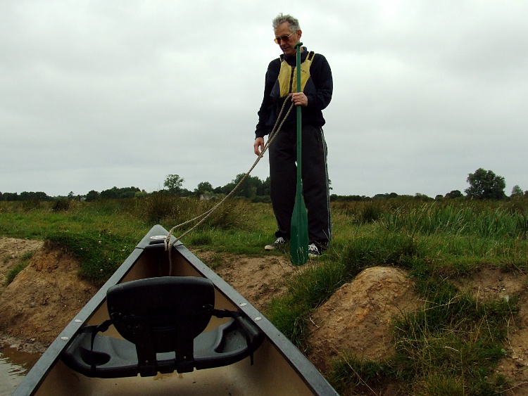
Mike and Mary were staying with me for the weekend. On the Sunday we left Mary, Mike's wife, to go shopping, or whatever it is that women like to do, and we popped down the road to Wayford Bridge and Banks' yard. By around 11:20 we were equipped and had had our safety briefing and were ready to go, with three hours of exploring ahead of us.
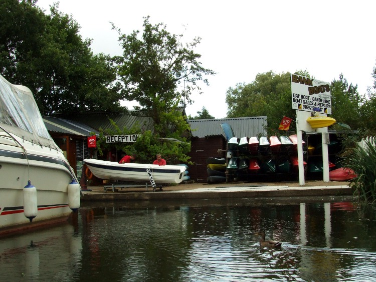
Banks Boats is at the end of a dyke to the south of the west side of Wayford Bridge. Apart from hiring canoes, kayaks and day boats, they also offer sales and maintenance services.
Mike had long been wanting to hire a canoe on my local river. Back in June Diana and I had gone Canoeing from Wayford Bridge and that had made Mike that much more determined to have a go.
Just north of Wayford Bridge you pass some house boats that I remember from the early 1960s. The look a little tatty now and are close to the busy A149, so they wouldn't be my favourite holiday home.
As we set out we had no clear idea about priorities. We ended up taking the right turn after the houseboats, heading for Honing Lock. I guess that was because Mike had never been up that channel. Dad used to have his boat moored at Dilham, so we both had memories of the the route, via Tyler's Cut, to Dilham, which was the other choice.
The North Walsham and Dilham Canal
Having made our choice we were truly on the North Walsham and Dilham Canal. I have always understood that the initial part of the route towards Dilham is the River Ant then, halfway to Dilham, the main channel becomes Tyler's Cut. This is an expansion of a tributary of the Ant, a small stream that rises beyond Dilham. The Ant itself seems to get lost in one of several dykes that must have been cut to provide access to the river which, back then, would have been the main transport route.
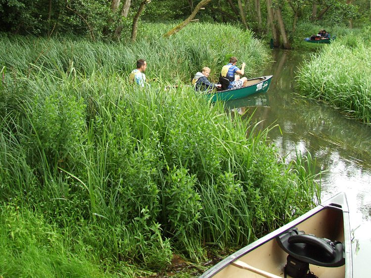
A few yards up the canal we could hear much youthful screaming ahead. Eventually a pair of canoes came into view. By the time they passed us composure had been restored and all seemed under control except the craft with the youngster in. That was now under tow.

With the youngster's canoe now under tow composure is restored and we are offered a sweet smile.
Another few yards further on I manage to take a photograph of the tumbledown wreck of a boat house that I mentioned in my report on the trip with Diana. These days it would appear to be completely isolated. Not only is there no house nearby, but Googe's satellite images suggest that a drainage dykes behind it would prevent access to it from the field behind. I have found it impossible to find on Google Maps. It's so well camouflaged by the surrounding trees and ivy growing across its roof.
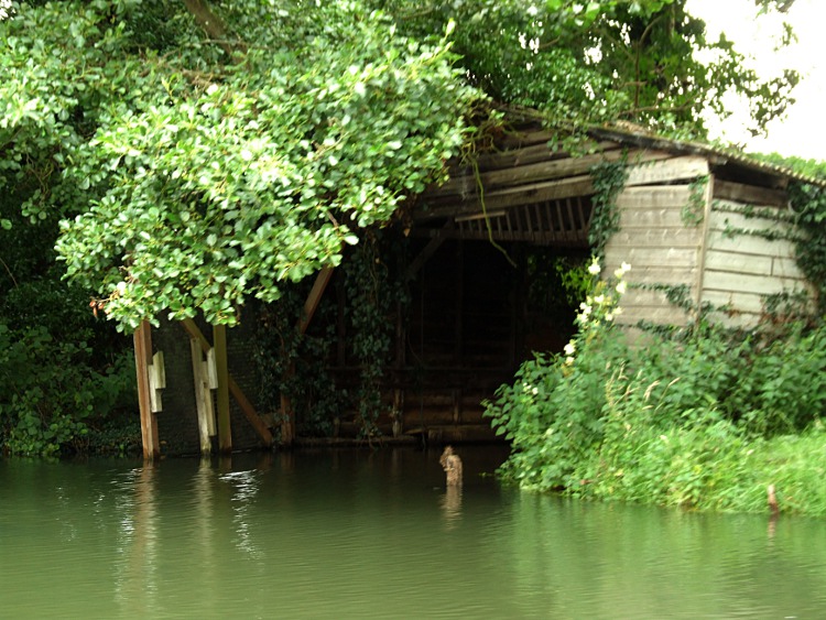
This tumbledown boat house is cut off from the fields behind by drainage dykes and there is no house nearby. You can't help but wonder who owned it, when it was last used and what kind of boat was kept here.
By the time we passed the boathouse the antics of the family in the pair of canoes had been forgotten and tranquillity had returned to the canal. Although even Mike and I proved too much for a swan which moved serenely out of the way as we approached and took to more sheltered waters by the bank out of the main channel.

This swan didn't seem to interested in us and nonchalantly headed for the bank as we passed by.
The scenery was as I had remembered it with Diana. The trees gave way to slightly more open country. There were geese moving about on our left and the highland cattle were still there, though I didn't notice the big black monster I had photographed the last time.
Tonnage Bridge soon came in sight. This time I was pleased to be able to confirm that the day boat that Diana and I had encountered did, indeed, belong in these waters for there it was in the boathouse beside the bridge.
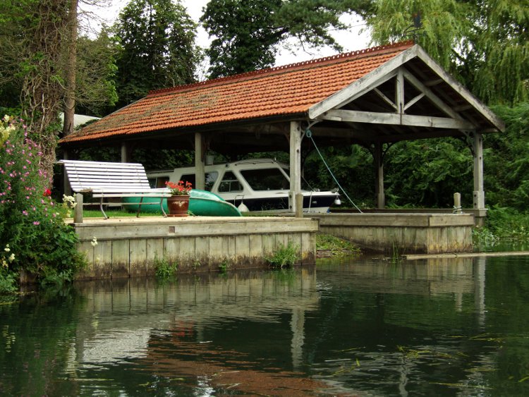
This time the owners of the cottage beside the bridge were at home - or, at least, not out on the water.
Once north of the bridge Mike and I were in waters that were new to both of us. Now the fields stretched away on both sides, although the canal itself was lined with a scattering of trees, some of which were long dead, and shrubs, some overgrown and one, in particular, leaving little room for us to get past.

The tree ahead seemed to have fallen but that hadn't stopped it growing, so we had to manoeuvre round it.
For the most part the canal was lined with reed and it was hard to make out anything of the fields beyond. When we encountered a wider part of the canal with a shallow sandy bank, Mike wanted to explore and take a better look at the surrounding land. The way much of the bank was clear of any vegetation made me think it was an area where cattle would drink.
I think Mike just wanted to see how easy it was to beach the canoe and land with out getting wet.
Once ashore Mike didn't seem to want to stay long and after a very perfunctory stare around he was back n the canoe again. We paddled on again, now with the canal seeming to get ever wider.
The East Ruston Branch
Eventually, we reached a fork. To the right, I knew, was the East Ruston Branch. In the distance I could see the distinctive stand of dead trees I had seen when walking the Weavers Way. They surround some of the lakes near the village and are used by anglers. Presumably these are the same type of tree we had seen earlier on the canal banks. I really ought to find out why, in this area, there are so many dead trees about. If it's not some plague, like Dutch Elm Disease, then I have to wonder if there hasn't been some dramatic change to the water table. It seems that it is affecting a certain kind of trees while others appear to be surviving.
We made the choice to turn towards East Ruston. I can't recall how we reached that decision, but it may have been that I related the tale to Mike of how I had met a man at the Boat Jumble held at the Museum of the Broads who lived in the village. He had bought the canoe kit that I had spotted as Ian and I entered the sale and I encountered him in the Canal Trust's stand, pouring over the maps that showed his village. He was explaining how he hoped to be able to launch his canoe in the village at the head of the Canal Branch. I had mentioned this incident in my blog.

The canoe seemed more and more exposed as the canal widened. Ahead we could see still tree-lined waters. To the right was a more open weed-chocked channel. We made the choice to go right towards East Ruston.
As soon as you enter the weed encroaches on the channel and within a few yards extend the full width of the water, but we found you could paddle through it without any real difficulty. I had worried that such thick weed would indicate very shallow water but this was not the case. My paddle never hit the bottom, although the weed did make it harder than normal to paddle.
As you go a little further bushes and trees close in on the banks, the channel gets narrower and the weed clears. Then you see the bridge. It's low. It's where the Weavers Way crosses the route of the dyke. Once back home and looking at Google Maps, I realise that to the right in the last few yards before the bridge are ponds which presumably were the site of the staithe serving the village. However, we didn't notice any cut through. Presumably the original staithe was closed off as part of local land drainage improvements after the canal fell into disuse.

Mike was already talking about turning round when we saw the bridge. I was keen to press on.
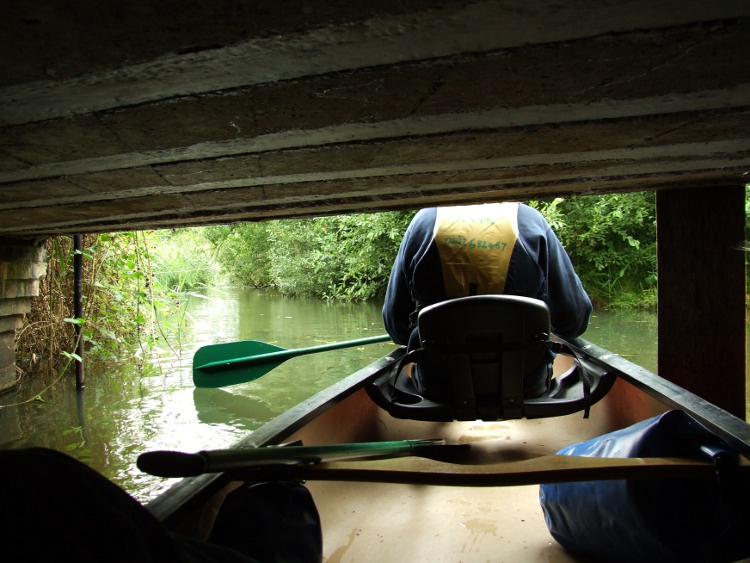
We made it under the bridge, pushing the canoe along with our hands on the concrete above.
I wasn't thinking about the staithe as we approached the bridge. For me it was a challenge to see if we could get under it. In any case I was keen to go further. I couldn't quite remember the geography of the area, and wanted to investigate whether you'd come close to the back gardens of the houses in Chapel Road. We made it under the bridge and went perhaps a 100 yards further before I agreed that the dyke was getting too overgrown and we ought to turn round.
After abandoning going further we turned round. Here we are approaching Weavers Way from the North.
As ever with these kinds of expeditions, it seemed less far on the return trip and nowhere was it quite as narrow as when we came up. We were soon paddling through the full width weed and then back at the junction with the main line to Honing.
At Honing Lock
The map, which Banks Boats supplied, suggested that the East Ruston Branch was at the beginning of a long sweeping curve. From the point where we re-joined the main line we'd travel west and a little way south before heading roughly Nor-Nor-West to Honing Lock. It was an interesting paddle.
At around this point I remembered "Saildroid", an application on my new phone. It will act as a compass, show current position, and how fast you are going. I wish I had used it to record how far up the dyke that we had gone. However, it was too late for that by the time I thought of it although, for amusement, I did get my phone out of the dry bag and set it to show our speed and direction. Thinking about it later I should have got the camera out to record our fastest speed as well.
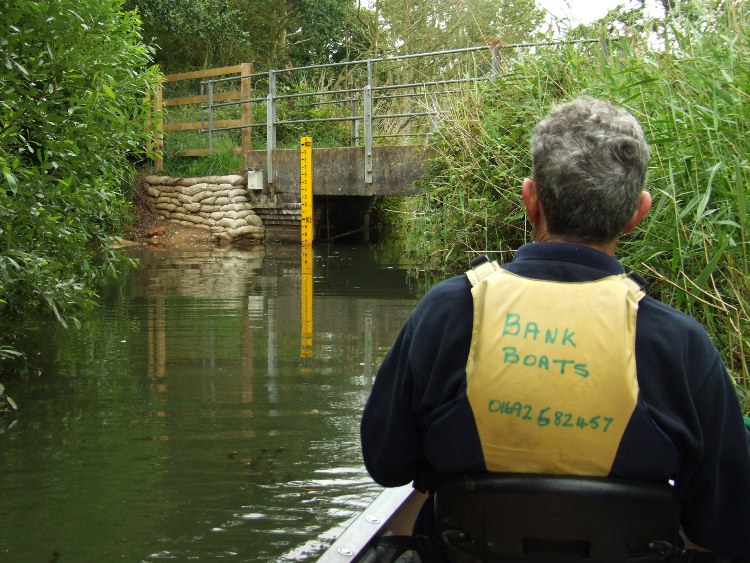
Initially, after the East Ruston junction, to our north were largely open fields, with trees at the water's edge. Then, just before the most southerly point where the canal begins to turn to the right and north again, thick woods appeared on that bank right up to the water's edge. Reeds, on each bank again made some parts quite narrow. As you reach the final four hundred yards before the lock, the woods close in on both sides. Although it appears straight on the map doesn't seem quite that way on the ground, as sprays of reed, first on one side then the other, prevent you from seeing more than a few tens of yards ahead. In the final few yards you begin to hear the sound of tumbling water and after a little dog-leg in the cut the trees open and reveal the lock.

We make our target! We enter Honing Lock and proceed as close as we dare to the weir at the far end.

We're surprised to see an approaching canoe. As we turn to exit the lock, it makes a left turn and goes out of sight.
The lock is much as I expect it to be, lacking gates and with foliage growing from between its bricks. As we approach the weir at the far end and canoe comes into view. I manage to take a photograph before it disappears out of view to our right. By using the gate recesses we are able to turn our 15'8" canoe within the lock. We then made an exit and beached the canoe just below the lock.

As we take a rest Mike stares at the paddlers we had encountered before our excursion to East Ruston. They had reached the lock before us and were now taking a meal break.
As we contemplated the scene. Mike took an interest in the other canoe that had passed us while we were exploring the East Ruston Branch. Their's was a private boat and the two paddlers had pulled it fully onto the bank. I wondered if they planned a portage round the lock after their break. Mike had just suggested that it was time that he took the aft seat in our canoe when there was a rustling in the undergrowth behind us...

I'd forgotten about the canoe from upstream and was taken by surprise by a sudden rustling in the undergrowth. The canoe from upstream had obviously found the by-pass channel.
With no acknowledgement from its crew, the canoe emerged into the main cut and proceeded into the distance.
I had completely forgotten about the canoe from upstream and didn't remember seeing what must have been the lock's by-pass channel as we had approached the lock. But behind us three heads could be seen above the reeds. It emerged onto the main channel and disappeared round the corner.
Mike and I resumed our conversation. I accepted the front seat and we set off for the return to Wayford, and the hope that we would have enough time to make it up to Dilham in the three hours we had available.
The Return to Wayford
Diana had appeared happy to accept the front seat in the canoe we hired without argument, but I could understand why Mike might want a go in the "steering seat" and happily gave it up. I was, in any case, quite curious to see how different it would be to what I had expected. And different it was. My instinct appeared to be to thrust in the wrong direction if I wanted to aid the steering.
To some extent Mike needed to get into his stride too. I probably didn't help as I realised I wasn't always being as helpful as I intended. My strokes that were intended to compensate for the inevitable turning effect when pulling on one side of the boat did not appear to work. And, of course, we were doing all this is a narrow bending reed-lined channel.

The narrow channel and tight bends in what maps show as straight didn't aid our learning new paddling roles.
We were soon back at Tonnage Bridge. South of the bridge, at the bottom of the cottage garden, I persuaded Mike to pull in so I could read a planning notice that was attached to a post on the river bank. It turned out there was an application to erect an array of solar panels. I was also able to photograph the Highland cattle in the next field, although the impressive black creature I had seen when I was with Diana was not to be seen.

The approach to the restored, or is it new, northern side of Tonnage Bridge? It may just have been widened.
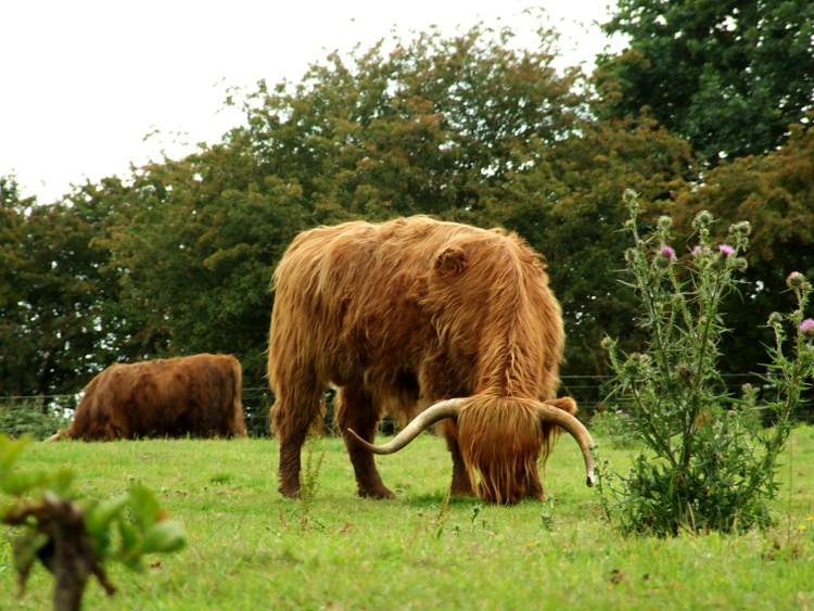
I couldn't see the big black bull that I had photographed last time, but the highland cattle were still on the field.
Finally, the sun was beginning to break through the cloud and it got noticeably warmer. Just after we passed the tumbledown boat house, Mike decided it was time to shed his sweatshirt. He showed off the shirt I had bought him when we took part in the 2006 Three Rivers Race.

"Have you noticed my shirt?" Mike asked as his Three Rivers Race 2006 shirt was revealed.
As we closed on the junction with the main river, we encountered another family group. this time there seemed to be a girl in her own kayak, while her younger brother father and grandfather followed on in a Canadian canoe. She was clearly an experienced paddler, turning on a sixpence (or should that be five pence, these days?).

The kayak spins as its paddler appears to want to check on the progress of the rest of her family.
Towards Dilham from Wayford
As we reach the junction with the main river we've taken a bit over two hours. It's going to be a rush to reach Dilham and visit Dad's old mooring, especially as I then ask Mike to slow down as we pass the mill cottage so I can get a better snap than last time.

At the end of a 400 yard drive you can understand why this isolated cottage offers popular holiday accommodation.
We're soon at the head of Tyler's cut and we turn straight into the first dyke, t be greeted by a boater working on his cruiser. We exchange pleasantries and work our way round the corner towards Dad's plot, which was one of those furthest to the back of the moorings. We get there and it's much as we both remember, except for a lot of weed.
The sign directs you to "Dilham Staithe and Turning Point", discouraging manoeuvres near the private moorings.
Dad bought his mooring in 1973, when the dykes had only just been cut. Back then there was a lot of bare mud, so when I say "much as we remember it" I was thinking in terms of general development. People did cultivate their plots to some extent in Dad's day but, as I recall, there were some fairly restrictive covenants in place, and little more than low boundary fences and hedges were allowed. Mike recalled that Dad had planted a hedge, but it looked as if the original had been grubbed up, as all that was there when we visited was neatly mown grass.
Dad's mooring is now occupied by the small day launch on the right. The dyke needs to be cleared of its growth.
It was getting late and as we exited from the moorings. Mike insisted that we didn't have time to go the extra 250 yards to the public staithe and head of navigation and he was right. I was only allowed time to take a photograph of the entrance to the dyke and then we set off back to Wayford.

My parting shot of the dyke that leads to Dad's mooring. Just take a right turn beyond the moored boats.
As we hurried back to the Bank's yard, we saw none of the big hire boats that Diana and I had encountered. Indeed, the only boat we saw was one small private cruiser.
Tyler's Cut was much quieter than when Diana and I were on it. "Sarah" was the only boat we saw under way.
As we reached the houseboats, just north of the bridge, I spotted as heron and again we slowed so that I could grab a photograph. There were only minutes to go before our time was up.
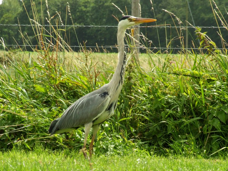
Striding up and down the bank opposite the houseboats, this heron seemed to be especially posing for the camera.
After that it was time to concentrate on making it back to the boat yard and we set to it. The bridge was only just ahead. Through that and we were back.
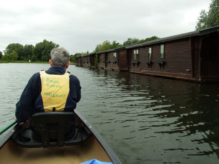
While traffic on the A149 does tail off after dark, the houseboats can't be the quietest holiday accommodation.

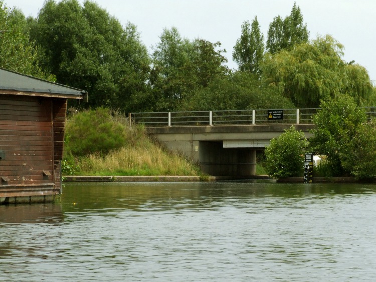
Under the bridge and the sheds of Wayford Marine are visible, where "Just 17" is being repainted.
As we emerge from the bridge we only have to go a matter of yards. We turn to the right and aim for the stack of canoes at the end of the dyke. We are probably a few minutes over the three hours for which we paid. It only then occurs to me that the yard doesn't issue any kind of ticket to remind you when to return. However, it doesn't seem to matter and the company don't appear to be close clock watchers, helping us as we come alongside and then hauling the boat out of the water.
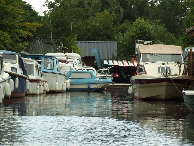
The view from the main river of Banks Boats. Most of the boats in the dyke are for sale through the company.
The last half hour was perhaps more tiring than it should have been. Our fault! We did try to pack in more than we should have done. However, as far as I was concerned it was another thoroughly enjoyable experience. I just wish I could have recorded what I learnt about being in the front of the canoe, but I fear that I have forgotten it all and will have to re-learn it again next time I am out.